
Connect the context
Bring together information from enterprise systems, assets and physical environments.
Helios is the spatial operations platform for complex sites. It brings 3D environments, assets, work orders, and live data together in one view, so teams understand what's happening and act with context.
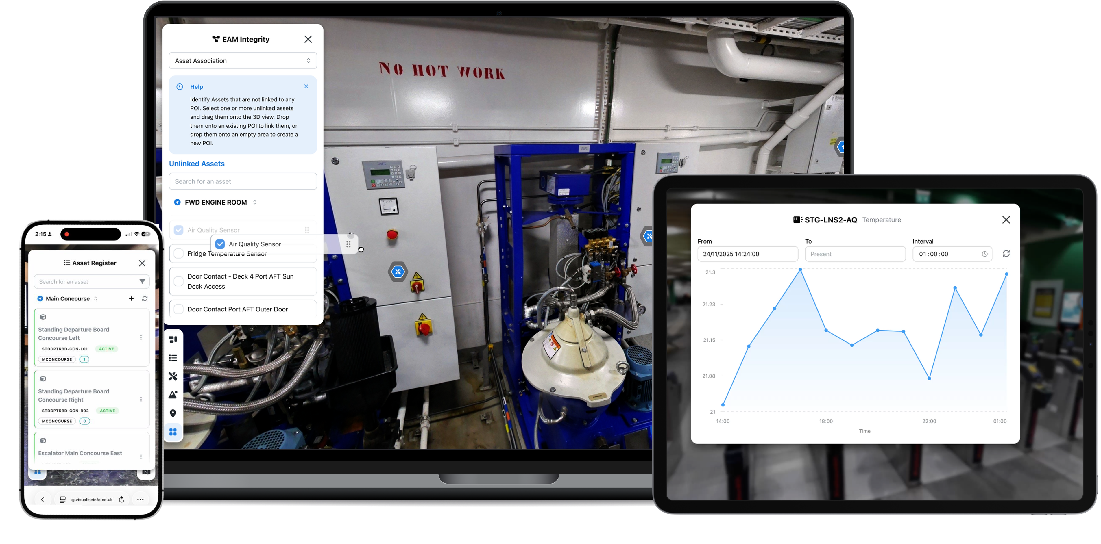
Helios turns static EAM records and live sensor feeds into a fast, interactive 3D workspace. Effortlessly navigate massive point clouds straight from your mobile browser to verify equipment conditions, monitor live readings, and bring your physical site and digital records into total alignment.
Built to Simplify, Designed to Scale
Explore Heliosby Visualise Info
Visualise Info developed GraphQL for IBM Maximo to give your application a more flexible, consistent way to access, navigate and update Maximo information, simplifying integration while keeping Maximo as the underlying system of record.
Explore GraphQL for IBM MaximoVisualise Info connects enterprise data, assets and physical context to help people understand what matters and act on it. We develop focused intelligence for the systems, assets and environments where decisions happen.
Bring together information from enterprise systems, assets and physical environments.
Develop compact, domain-focused Small Language Models that can interpret specialised asset, sensor and operational information in context.
Make important conditions and relevant information easier to recognise.
Put useful context where people make operational decisions and carry out work.
Our work includes organisations responsible for complex facilities, infrastructure and operational assets. Helios is configured around the environment, information and workflows in scope for each engagement.
Review equipment, site imagery and available sensor information through the location they relate to.
Use a shared spatial view to understand where assets sit and what surrounds planned work.
Connect current and historic readings to the relevant equipment or location so teams can review them in place.
Give office and site teams the same reference for assets, records, instructions and supporting documents.
Explore layouts, assets and supporting information through a navigable representation of the environment.
Provide configured routes, stops, maps and written instructions through complex indoor environments.
Give teams a shared visual reference when the available imagery and operational information are sufficient for off-site review.
Connect asset records, work information, documents and location context when planning or reviewing activity.
Use a shared spatial view to understand layouts, equipment locations and the information connected to them.
Bring asset records, work information and visual site context together before work begins.
View current and historical sensor readings beside the relevant equipment or area.
Connect instructions, documents and media to the place or asset where teams need them.
Connect available HVAC and environmental readings to the room or equipment they describe.
Give estates teams a visual reference for spaces, assets, records and current work.
Review imagery, asset information and recorded conditions away from site when the available context is sufficient.
Use permissions and focused views to present relevant location, asset and supporting information.
Explore physical layouts alongside the asset and location information used to manage them.
Connect manuals, work information and supporting media to the relevant asset or location.
Place current and historical readings beside the equipment they relate to.
Give shore, port and vessel teams a shared visual reference for reviewing an issue or planning work.
Bring imagery, asset records and available operational information together around the physical environment.
Use the shared spatial view to assess an issue away from site when the available information provides sufficient context.
View current and historical readings at the equipment or location they describe.
Connect work information, documents and site context for teams preparing or carrying out activity.
Complex enterprise systems only create value when people can understand and use the information they hold. Visualise Info bridges that gap with spatial software, enterprise integration experience and a practical focus on how teams work.
Our work spans EAM, assets, locations, work information, IoT and the operational relationships between them.
We connect spatial software to EAM, IoT and content platforms while those systems remain authoritative sources of information.
Helios is developed by Visualise Info, giving us direct control over the spatial experience and the integrations around it.
Responsive interfaces, accessibility considerations and cloud or on-premises options help Helios fit office, site and organisational needs.

We work with consultancies, integrators and resellers that understand their clients' environments and operational priorities. Visualise Info brings the Helios platform, product expertise and enterprise integration experience; partners bring sector knowledge, delivery relationships and complementary services.

We work where physical places, enterprise asset management and operational data meet. Our focus is making specialist information easier for facilities, engineering, asset and operational teams to understand and use.
We develop Helios, including our own 3D viewer, and the integration capabilities that connect it to enterprise systems, IoT data and content. Our experience includes established IBM Maximo integration, alongside delivery through the Visualise Info cloud or on premises.
Our experience includes organisations responsible for property, transport, public services and complex operational environments.






Tell us about your environment, operational challenge or partnership enquiry. We will route your message to the right person at Visualise Info.
Share what you are trying to understand, connect or improve, and we can discuss the most useful next step.
Fuel Tank, 8-12 Creekside
London, SE8 3DX